Announcement

Collapse
No announcement yet.

Giant. Thing. NSFW.

Collapse
X
 
  • Filter
  • Time
  • Show
Clear All
new posts

    #61
    I leave for a day and soembody finds out what it is and spoils the fun. and apparently my thread is NWS now. hahaha

    Im still going there. to see if I can even get close youd think id be able to see a giant beacon tower over the trees.
    -Will

    Comment


      #62
      Originally posted by JoshM View Post
      How much is the government paying you to say such things?


      KeepinItClean | EnviousFilms | NoBigDeal | YET2BSCENE | .· ` ' / ·. | click here.
      Originally posted by Jarrett
      Is there a goal you're trying to accomplish besides looking dope as hell?

      Comment


        #63
        Balls. Oh well.

        life is good.

        Comment


          #64
          Originally posted by Bullhorn7 View Post
          Im still going there. to see if I can even get close youd think id be able to see a giant beacon tower over the trees.
          go to google earth, zoom in and look at the shadow the tower in the middle is casting.. not exactly large enough to see from a distance, especially through trees.. or just look at the google images i mentioned in my previous post..

          Comment


            #65
            Originally posted by visualpoet View Post
            I'd just like to point out that I was closest to the actual object.
            Id say the sign was the closest - "This facility is used in FAA Air traffic control"


            As I said in my first post:

            Originally posted by evil_demon_01 View Post
            You Americans are way too Paranoid about, practically EVERYTHING


            Car Safety / General Servicing Checks --------Basic suspension checks

            My 5.7 LS1 Holden Ute

            A "Finished" project car is never finished until its been sold.

            If at first you don't succeed, Try again. Don't give up too easily, persistance pays off in the end.

            Comment


              #66
              Originally posted by evil_demon_01 View Post
              Id say the sign was the closest - "This facility is used in FAA Air traffic control"


              As I said in my first post:
              Who was paranoid? No one that i saw

              Just some curious people. Thats all...

              Comment


                #67
                Originally posted by evil_demon_01 View Post
                Id say the sign was the closest - "This facility is used in FAA Air traffic control"
                Okay, the sign was physically closest.

                Comment


                  #68
                  Originally posted by MikeW View Post
                  Unlikely. Albeit, they dont like people knowing too much, they do love hype.


                  There will be no choppers. It is a communication device used for aviation of some sort. Airplanes flying 35k above it are ok but close proximity choppers are a no-no.


                  Have you met the US Government? I have. In Arizona, there's an area called the Yuma Proving Grounds - (http://en.wikipedia.org/wiki/Yuma_Proving_Ground)[Mapquest was "unable to locate" it on a map...] Look it up. Highway 95 runs North, out of Yuma, to a little town called Quartzsite. The proving grounds encompass about 40 miles of that highway. Along which, are signs, about 50 feet off the highway that state it is government property and that trespassers WILL BE SHOT. We stopped one time, to let our dog go to the bathroom, and we werent stopped for more than a few minutes when we were approached by a black suburban occupied by, at least, 2 guys in army fatigues. The one that got out, did have an automatic rifle of some kind on his shoulder. He asked us what we were doing. When we told him, he said, "When the animal finishes doing it's business you folks need to go on and get moving." I shit you not. My dad, who lives there, says that if you ever break down, you dont have to worry about calling a tow truck because you wont have to sit there long before a little black truck comes along and theyll do whatever they have to in order to get you on your way.
                  Go to youtube and look up Area 54 videos. Our government doesnt want us in certain areas. They wont tell us why or what they're doing. We feel we have the right to know.


                  If you're referring to the sign saying "loss of human life" they mean that if you drive up there with your car or walk around and theyre forced to shut it down, that planes could fall from the sky. Albeit scary, and a scare-tactic, planes dont just fall out of the sky. Our satellites dont keeo the engines running; gas does. Our instruments tell them where they are, but they dont keep them airborn.


                  Oh shit. Now i may a bit of a theorist, but dont start with that shit. Fucking Georgia guide stones and all that shit.
                  Originally posted by visualpoet View Post
                  I've seen a couple of identical signs before, but they're usually on a fence surrounding some antennas, as well as a building. The look of that thing from the top makes me think it's some kind of passive location beacon transmitter. It would be interesting to see some pics from ground level.

                  Oddly, I've seen the same 'sundial' construction on Google Earth in the desert out around Vegas, minus the grass of course. I came across it when I was looking for cool things to go look at while in Vegas. There's a lot of odd things out there, including a couple full scale duplicate Russian towns used to plan invasion procedures, plus a lot of things carved into the desert to assist training soldiers to fire the long range weaponry. Some of it takes some looking for on Google Earth, but it's pretty crazy when you see it.
                  Originally posted by DJ metadelic View Post
                  In response to most of these posts, I'm sure most of you in turn realize that what we think we know about what the government does, is probably 10% of what they actually do.

                  I'm not big on conspiracy theory, in general. Speculation is one thing, I like to see proof.

                  This, to me- doesn't look like a communication device or complex alone. Why would it be so intricate? I understand why they don't want civilians on premises, but c'mon. Even with craft flying miles above earth, you'd think a simple tower structure would suffice.

                  I'm not saying it's a giant US government cover-up. That this is where flying saucers land...But, I would survey the area and look for more neat stuff. They like to leave us clueless; that's whole point.
                  Originally posted by MikeW View Post
                  Buddy of mine says it looks alot like some missile silos he's seen in the Ozarks, before. Said they had the same kind of signs up and everything.

                  Originally posted by Ralphie View Post
                  Im going to stick with the idea that it is used for Aircraft traffic control.

                  There are so many variables.

                  Obv planes work on GPS but that is one small sliver of aircraft flying.

                  I wish Scott would chime in, hed have a good idea.

                  I doubt it is for anything really crazy but i guess ya never know.

                  What i DO KNOW, is that going beyond those gates will and can get you and whoever else is with you SERIOUS consequences.

                  Even if all they want to do is escort you off the property if someone makes the wrong move you could end up in a body bag.

                  As much as this shit excites me and i like investigating i would be very careful because by law your in the wrong and they don't have to ask twice.

                  Good luck!
                  Originally posted by The G-Man View Post
                  This 'thing' is northwest of BHM airport. It is the VULCAN Vortac.

                  http://skyvector.com/?ll=33.69603564...hart=29&zoom=2

                  Go to this page and type vulcan into the box:
                  http://www.airnav.com/navaids/

                  More info on VOR and VORTAC.

                  You guys are retards.
                  Originally posted by Tippey764 View Post
                  Who was paranoid? No one that i saw

                  Just some curious people. Thats all...
                  The definition of paranoia is assuming anything you don't know about is bad or some conspiracy. Nearly every post in this thread is paranoid. "OMG! It's totally a government conspiracy."

                  G-man pretty much already took care of it, but here are some additional images.


                  You can see that they come in a variety of configurations, locations and sizes.

                  VOR stands for VERY HIGH FREQUENCY OMNIDIRECTIONAL RANGE, or VHF Omnidirectional Range.

                  The VOR is essentially the main form of over land navigation that was used prior to the advent of GPS. Now that we have GPS, it is still widely used (many older aircraft are not GPS equipped, and it makes a good backup).

                  There are also a lot of what are called "instrument approach procedures" based on these VOR's. We also have departure and arrival procedures based on these stations, in addition to the cross country navigation function.

                  The reason an interuption in service could result in a loss of life is because when an aircraft is navigating based on one of these stations in weather where they can't see, they depend on the VOR to give them guidance and situational awareness so that they can use the instruments to keep them from colliding with objects they are not supposed to collide with. If they are using the station and it suddenly goes down, and they don't have an alternate means of navigation, then they lose situational awareness, because they can't see the ground or obstacles. The best way I can think of to illustrate this is for you to stand in a dark, unfamiliar room and try to walk around without running into stuff without putting your hands out in front of you. Doesn't work too well does it? Now imagine you are the airplane, the dark is the cloud cover and the "objects" are mountains. Obviously, we need to figure something else out, don't we?

                  Yes, Mike, you are correct that planes won't just plummet out of sky, but you are incorrect in assuming they are not critical, because while they may not plummet out of the sky, they may in fact plummet directly into the Earth. I think it goes without saying what the outcome of that is likely to be.

                  Now, the way they work is actually pretty cool.

                  They send out 2 radio signals. The carrier signal and the phased signal (don't remember the technical term and I am not going to look it up). What happens is that when I am due north of the station (magnetic 360* course, not true north) both frequencies are perfectly in phase. As I move to the 90* (magnetic East) position, the two frequencies are now 90* out of phase, and they get there 1* at a time (a heading 10* east of north would put the signals 10* out of phase). As I get to magnetic south (180*), the frequencies are 180* out of phase and finally, west puts them 90* out of phase in the other direction. The aircraft is equipped with radios that can measure the difference, and tell me what my exact line of position is in relation to that station, based on the fact that each degree from north = 1* of phase difference.

                  Thus, I can determine my line of position from the station, and then combine that with my aircraft's heading and altitude, to determine not only where I am in space, but where I am going. I can also make any corrections necessary to change my course or position precisely to move from predetermined Point A to predetermined Point B, along a specific course or heading, thus allowing me to stay out of the ground and obstacles. Combine that with altitude and I now have 3 dimensional knowledge of where I am, and what is around me, without being able to see the ground. I can use this to make sure I either climb or descend on precise courses, or navigate cross country on precise courses, allowing me to get from point A to B without getting lost in bad weather.

                  Most VOR's also incorporate a technology called DME, which stands for Distance Measuring Equipment. This is a seperate frequency and transmitter/receiver that is automatically coupled to the VOR (when I select a specific VOR, I automatically get the appropriate DME frequency). What this does is allow me to determine my straight line distance from the station that I am navigating to. Couple this information with my line of position and altitude, and I know PRECISELY where I am at.

                  The way it works is that the aircraft sends a query to the DME station, and it transmits a reply. Since radio waves travel at the speed of light, the radio on the aircraft can calculate a distance based on how long it took from the time it interrogated until it received a response.

                  The entire purpose of these stations is to be able to get places when you can't see the ground (what we refer to as instrument flying). This increases our ability to fly in low visibility and bad weather, which is why fatalities could occur if service is lost. Hence the FAA sign.
                  Last edited by owequitit; 01-05-2011, 09:12 PM.
                  The OFFICIAL how to add me to your ignore list thread!

                  Comment


                    #69
                    Well, Scott, you didnt tear us all new assholes. Thank you. I am a bit of a theorist, lol. And a retarded one at that.


                    Originally posted by owequitit View Post
                    Ive seen this before. Isnt it used in GPS shit?


                    KeepinItClean | EnviousFilms | NoBigDeal | YET2BSCENE | .· ` ' / ·. | click here.
                    Originally posted by Jarrett
                    Is there a goal you're trying to accomplish besides looking dope as hell?

                    Comment


                      #70
                      Originally posted by JoshM View Post
                      How much is the government paying you to say such things?
                      Government is paying me. Not for this information though...
                      Gary A.K.A. Carter
                      [sig killed by photobucket]

                      Comment


                        #71
                        Originally posted by MikeW View Post
                        Well, Scott, you didnt tear us all new assholes. Thank you. I am a bit of a theorist, lol. And a retarded one at that.


                        Ive seen this before. Isnt it used in GPS shit?
                        Nothing to do with GPS at all. Just a radio navigation aid.
                        Gary A.K.A. Carter
                        [sig killed by photobucket]

                        Comment


                          #72
                          Originally posted by owequitit View Post
                          Nearly every post in this thread is paranoid.
                          I beg to differ....my post wasn't paranoid....i was positive it was equipment used by the FAA as it clearly states it lol but of course since i didn't have proof i couldn't be 100% sure

                          Anyway thank you for the post, lot of good information there!

                          Comment


                            #73
                            Thats 2012 :O

                            Comment


                              #74
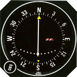
                              Using VOR's is fun, especially listening to the morris code to identify them at first. Here's a picture of the instrument inside the plane you use to navigate to or from them, after tuning to the appropriate frequency.


                              My swap thread
                              Main relay proplems?--DIY

                              Comment


                                #75
                                Originally posted by MikeW View Post
                                Well, Scott, you didnt tear us all new assholes. Thank you. I am a bit of a theorist, lol. And a retarded one at that.


                                Ive seen this before. Isnt it used in GPS shit?
                                No. That is a VOR. GPS is a constellation of satellites in orbit that transmit a signal all the time called Pseudo Random Code. It is called that because it is so complex, it seems random, but really isn't.

                                The GPS receiver knows what code is going to be transmitted and when, and compares the time difference between when it knows it was transmitted and when it was received, thus giving a distance from the satellite using the same method as DME.

                                Realistically, you need 3 satellites for 2D location, 4 for 3D positioning (2D plus altitude) and in aviation, we require at least 5 to fly an approach, in case one were to fail. Basically, the GPS units use error elimination, so if they have 5 satellites, and 1 disagrees with the other 4, they disregard the odd one out, hence the requirement for at least 5. This function is called RAIM or Random Autonomous Integrity Monitoring. If we lose the required number of satellites, a warning flashes on the GPS display, and you must discontinue whatever GPS approach you are doing and find another way into the airport, or to another destination. Because the orbits of the satellites are known though, they can usually predict RAIM outages and inform you ahead of time as part of the pre-flight planning process. They are extremely rare these days.

                                However, the important part is that technically, GPS does not require any ground based systems, which means it is cheap and easy to use, hence its growing popularity. There are also a lot more satellites in orbit than the minimum needed, so it is also very reliable over most of the world.

                                Also, they do now have ground based stations called WAAS stations, which is short for Wide Area Augmentation System. What this does is help eliminate some of the position error inherent to GPS signals, by using a precisely located and surveyed ground station that sends out a signal in that area and basically gets received by WAAS capable GPS units that then use that signal to make the known position much more accurate.

                                This is a relatively new and emerging technology that is going to make GPS MUCH MUCH more precise and can actually allow you to fly within 200 feet of the ground on an approach (no reference to the ground) with more than acceptable tolerance. My home airport was actually one of the airports used to develop, test, and prove the technology before the FAA decided to use it. It works REALLY REALLY well. In fact, it works so well, that it will allow small airports with limited money to have approaches that are as accurate as the ILS (instrument landing system) featured at larger airports. They are also able to get you down to 200' or lower, but use very precise ground based stations to do so. This is good for system safety because it allows a greater level of accessibility and accuracy at airports that traditionally have not had it, and it is dirt cheap to do, because other than the WAAS station, it is usually a matter of programming.
                                The OFFICIAL how to add me to your ignore list thread!

                                Comment

                                Working...
                                X